


| Online: | |
| Visits: | |
| Stories: |

| Story Views |
|
| Now: | |
| Last Hour: | |
| Last 24 Hours: | |
| Total: | |
Hurricane Michael Makes Landfall Near Mexico Beach As Cat 4 Storm +Videos

By Tyler Durden / ZeroHedge
Update (1:40 pm ET): The “worst case scenario” has become a reality. Hurricane Michael made landfall near Mexico Beach, Florida at 1:40 pm as a Category 4 hurricane with sustained winds of 155 miles per hour (that’s 2 mph shy of Category 5 status). Already, the storm is the most powerful hurricane to make landfall in the Continental US in 14 years.
The storm is the most powerful hurricane to ever hit the Florida Panhandle. The catastrophic damage expected will likely knock out power in Bay County and further inland to Tallahassee and southern Georgia, Axios said.
BREAKING Hurricane Michael is making landfall on the Florida panhandle, the strongest storm to strike the region since records began in 1851. pic.twitter.com/8ghZ0AvZvp
— James Cook (@BBCJamesCook) October 10, 2018
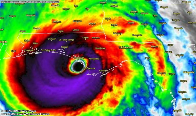
Update (1 pm ET): The NHC has published the latest positioning update on Hurricane Michael. The storm, now about 20 miles from the Florida coast, is expected to make landfall between Panama City and St. Vincent.
Here is the 12 PM CDT position update for #Michael: Eyewall of Michael coming ashore along the coast of the Florida Panhandle between St. Vincent Island and Panama City. Do not venture out into the eye when it passes! pic.twitter.com/KsePFlnTIt
— National Hurricane Center (@NHC_Atlantic) October 10, 2018
As the eyewall of the storm approaches Panama City, one intrepid reporter offered a glimpse into the mayhem.
INTENSE eye wall east side of Panama City beach with Hurricane #Michael @accuweather@breakingweather pic.twitter.com/4exA2CD6xO
— Reed Timmer (@ReedTimmerAccu) October 10, 2018
Catastrophic wind in eye wall of Hurricane #Michael in Panama City Beach eastern tip @breakingweather @accuweather pic.twitter.com/nPPoBPZkai
— Reed Timmer (@ReedTimmerAccu) October 10, 2018
* * *
Update (12 pm ET): Now just 40 miles from Panama City, Hurricane Michael is still gaining strength as it approaches the Florida panhandle. The storm has apparently exceeded the expectations from the National Weather Service, which warned that it is a “worst case scenario” and will cause unprecedented devastation to the communities in its path.
Landfall of #HurricaneMichael is imminent. THIS IS A WORST CASE SCENARIO for the Florida Panhandle!! Listen to your local emergency officials. Stay Inside & Survive!” –NWS Director Dr. Louis Uccellini @NWSDirector pic.twitter.com/EMSZbMaHwW
— NWS (@NWS) October 10, 2018
Meanwhile, the NWS’ Tallahassee office said it issued its first ever “extreme win warning” for parts of Bay County that will soon be experiencing gusts of more than 130 mph.
The situation is about to get serious in parts of Bay, Gulf, and Franklin county. We’ve issued our first ever Extreme Wind Warning. This means wind gusts in excess of 130 MPH are expected as #HurricaneMichael makes landfall in the next few hours. Shelter in place IMMEDIATELY. pic.twitter.com/5nHmcKLGm0
— NWS Tallahassee (@NWSTallahassee) October 10, 2018
President Trump tweeted satellite imagery showing just how powerful the storm has become as it approaches the Florida coast, along with a message of support.
We are with you Florida! https://t.co/qzrVLeFbyFhttps://t.co/HVVhSmBg7Spic.twitter.com/rcB6OCwLeH
— Donald J. Trump (@realDonaldTrump) October 10, 2018
Meanwhile, scientists warned that Michael could strengthen into a Category 5 Hurricane before making landfall, as its maximum wind speeds of 150 mph were just 7 mph shy of the most dangerous category of hurricane, per USA Today.
“There doesn’t seem to be any opportunity for this storm to weaken at all, and it may strengthen,” said Brett Rathbun, a meteorologist with AccuWeather.
One thing’s for sure: Michael isn’t slowing down.
Watch a live feed of the storm’s approach below:
Meanwhile, President Trump is holding a live press briefing with FEMA:
Update (9 am ET): Hurricane Michael continued to strengthen Wednesday morning, as the Category 4 storm’s wind speed increased to 145 mph. The storm is now poised to be the strongest to hit the US in 14 years, boasting a life threatening storm surge and the potential to cause $16 billion in damages.
The storm is now roughly 90 miles southwest of Panama City and is heading north at 13 miles per hour, according to the NHC’s latest update. The storm’s outer bands are already battering the coastal town of Apalachicola with winds of nearly 50 mph.
Here is the 8 AM CDT position update for #Michael - water levels are rising and winds increasing along the Florida Panhandle as potentially catastrophic #Michael approaches. pic.twitter.com/lUQdldzMeG
— National Hurricane Center (@NHC_Atlantic) October 10, 2018
As it stands, the storm is also poised to be the strongest to hit the Florida panhandle and big bend since meteorologists first started gathering data. Regional ports have closed in anticipation, and more than 230 flights have been canceled. Duke Energy Corp., a utility that supplies electricity to the region, expects more than 200,000 customers in the state will be without power. In preparation for the widespread outages, local utilities have about 19,000 workers on stand by ready to work to quickly restore power, with more workers pouring in from out of state. Still, some areas are expected to be without power for more than a week, per the Daily Commercial.
“A storm like this could be a once-in-a-lifetime event,” said Brett Rathbun, a meteorologist with AccuWeather Inc. in State College, Pennsylvania. “Winds of this intensity can really knock down any tree or structure in its path.”
There are also 3,500 National Guard members, 1,000 rescue workers and 3,000 FEMA employees in the area ready to aid in the response. Michael is whipping up waves as high as 30 feet in the Gulf and could bring a 14-foot surge and 4 to 8 inches of rain, with some isolated areas getting as much as 12 inches.

As one meteorologist pointed out, the barometric pressure of the storm system has continued to drop, and only four hurricanes have ever made landfall in the Continental US with a lower pressure reading.
#Hurricane #Michael‘s pressure continues to drop – now to 923 hPa. Only 4 hurricanes on record have hit the continental US with a lower pressure: Labor Day (1935), Camille (1969), Andrew (1992), Katrina (2005). pic.twitter.com/i2zddUrWpU
— Philip Klotzbach (@philklotzbach) October 10, 2018
* * *
As residents of the Florida panhandle and big bend scrambled to flee their homes, Hurricane Michael strengthened to a Category 4 Hurricane overnight, putting it on track to rival the strongest storms to ever make landfall in that part of the country.
As one meteorologist pointed out, if Michael doesn’t weaken before making landfall late Wednesday, it would surpass Hurricane Eloise, which wrecked the panhandle in 1975, and the Pensacola Hurricane of 1882 for strongest winds ever recorded for a landfall in the panhandle. If the storm’s 140 mph+ wind speeds are maintained, Michael could be the strongest storm to hit the area since the dawn of record-keeping in 1851.
While Florida residents are somewhat accustomed to record-breaking storms, according to the Weather Channel, “no long-time residents of this area will have seen a hurricane this strong before.” Stores in the region have started rationing supplies like water and generators as residents have scrambled to stock up while state of emergencies have been issued in Florida and Alabama. The National Weather Service described the storm as “extremely dangerous.”
Hurricane warnings are in effect for the Florida Gulf Coast from the Alabama-Florida border to Suwanee River, Fla. This includes Pensacola, Panama City, Destin and Tallahassee. Warnings also extend inland to southwestern Georgia, including Albany. Hurricane Warnings are issued a day-and-a-half before the anticipated arrival of tropical storm force winds. Nearly 4 million people live in these areas, while another 8.5 million live in areas facing tropical storm warnings.

Emergency officials in Bay County, Florida – where Michael is expected to make landfall – said they are already witnessing deteriorating conditions due to the storm.

Amid warnings for residents to “get out” while they still could, Florida Gov. Rick Scott described Michael as a “monstrous storm”…
If you’re in an evacuation zone, I am urging you to leave RIGHT NOW. Do not risk your life or the lives of your loved ones- get out now.
— Rick Scott (@FLGovScott) October 10, 2018
…and issued mandatory or voluntary evacuation orders in at least 22 counties on the Florida Gulf Coast.

Scott also extended a state of emergency to 35 counties and activated 2,500 National Guardsmen. Georgia and Alabama have also declared states of emergency.
“Hurricane Michael is forecast to be the most destructive storm to hit the Florida Panhandle in decades,” Scott said. “You cannot hide from storm surge, so get out if an evacuation is ordered,” per CNN.
Along the North Florida coastline, the extreme danger will be storm surge. Gulf water will be pushed over the land at extreme depths – perhaps 10 feet or more – to the right of where the center comes ashore. “It will not be survivable in the affected coastal locations”, according to ABC’s Local 10 news.
A storm surge warning is in effect for much of the panhandle and big bend, where waves could measure between 9 to 13 feet above ground level, causing land along the coast to sink into the ocean as water climbs “over the roofs of houses,” Scott said.

President Trump has approved a pre-landfall emergency declaration to offer federal money to affected areas.

Here’s a roundup of storm-related warnings, courtesy of the Weather Channel:
Tropical storm warnings are in effect from the Alabama/Florida border westward to the Mississippi/Alabama border, from Suwannee River, Florida, southward to Chassahowitzka, Florida, and along the Southeast coast from Fernandina Beach, Florida, to Surf City, North Carolina. The tropical storm warning also extends inland to portions of southern Alabama and southwestern Georgia, including Mobile, Alabama, and Valdosta, Georgia. This means tropical-storm-force winds are expected somewhere within the warning area within 36 hours.
Tropical storm watches have been posted from Chassahowitzka, Florida, to Anna Maria Island, Florida, including Tampa Bay, from the Mississippi/Alabama border westward to the mouth of the Pearl River and also along the Southeast coast from South Santee River, South Carolina, to Duck, North Carolina, including Pamlico and Albemarle sounds. This means tropical-storm-force winds are possible within 48 hours.
Already, hurricane strength winds have started whipping the panhandle, forcing the National Weather Service has issued a tornado watch.
Tornado Watch is now in effect for much of the area. Know NOW where your safe place is going to be! https://t.co/KrP5QxANbT
— NWS Tallahassee (@NWSTallahassee) October 10, 2018
Closer to the center of the storm, which is now within 120 miles of Panama City, Fla., meteorologists have measured winds of more than 140 mph.
Here is the 5 AM CDT Position Update on #Michael. Aircraft data indicate that the central pressure has decreased to 937 mb – 27.67 inches. https://t.co/1OTHyJkqja pic.twitter.com/uUyUDMxydh
— National Hurricane Center (@NHC_Atlantic) October 10, 2018
Between Tyndall Air Force Base and Keaton Beach, heavy rainfall is expected across a large portion of the southeastern US along Michael’s track, with the rains expected to stretch well inland. Meanwhile, storm surge watches, which means life-threatening surges remain a possibility, are in effect from Anclote River to Anna Maria Island, as well as Tampa Bay.
Michael is expected to inundate a large portion of the southeastern US with rain, with up to 12 inches falling in the panhandle and big bend, as well as southeastern Alabama and southern Georgia. Some parts of the Carolinas, which are still recovering from Hurricane Florence, and southern Virginia could endure up to six inches of rain.

…As the storm moves inland this week.

Residents and business that are within the areas under mandatory evacuation order have only “a few precious hours” left to prepare before the storm’s landfall. Most customers in the hurricane’s path will likely lose power during the storm, and utilities aren’t certain how long it will take for power to be restored. Outages may extend into east Georgia, southeastern Alabama, the Lowcountry of South Carolina and southeast North Carolina given Michael’s faster movement.

The storm’s outer bands have already soaked parts of the Florida Keys. To put Michael in context, only three Category 3 or higher storms have struck the Panhandle since 1950: Eloise in 1975, Opal in 1995 and Dennis in 2005. Six airports in the Florida panhandle have closed ahead of the storm, while 40% of oil production in the Gulf has been shuttered ahead of the storm, helping to keep WTI crude prices elevated around $75 a barrel, as Michael has become “the top concern for the oil market this week,” per one analyst.
Read more great articles here: ZeroHedge


I like how you can tell on BIN where Users of this site come from by the articles posted. There is always a Lower amounts of editors pick’s when a Hurricane crosses America
I will now wait for the man made Hurricane posts